Updated 8:00 am EDT Thursday August 31, 2023
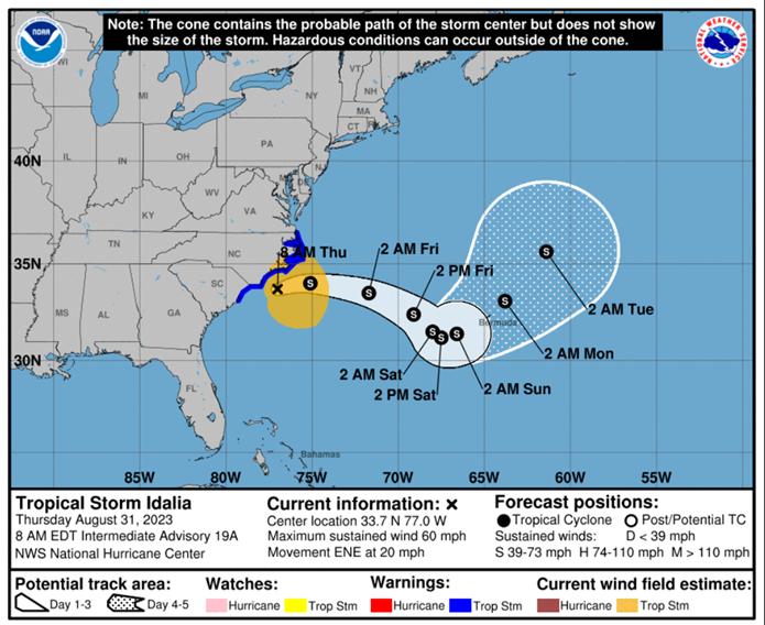
As of 8:00 am EDT on August 31, Idalia was downgraded to a Tropical Storm, with sustained winds of 60 mph.
Idalia has moved off the coast of northeastern South Carolina where its strong winds and heavy rainfall continue and are expected to affect eastern North Carolina.
Here are the key points from the National Hurricane Center:
Areas of flash, urban, and moderate river flooding, with considerable impacts, will continue across coastal North Carolina through today.
Coastal flooding is expected within the Storm Surge Watch area in North Carolina today. Residents in these areas should follow any advice given by local officials.
Tropical storm conditions are expected in northeastern South Carolina and portions of eastern North Carolina today.

Now that the storm has mostly moved offshore, focus will now turn to recovery activities in the areas impacted. It is critical to remember that, although the storm has passed, there are still significant dangers which exist and safety should remain top priority for all.
Below are some key reminders of critical steps to take during the recovery efforts.
- Only return to residence and/or business once authorities have indicated it is safe to do so. Enroute remember not to drive through any flood waters or touch any downed power lines.
- Do NOT energize any electrical/mechanical equipment that was exposed to flood or rain water until it has been inspected by qualified contractor.
- Photograph/video any damaged property and notify insurance carrier as soon as possible.
- If you sustained damage, engage a remediation company as soon as possible to mitigate and prevent additional damage.
- Make only temporary repairs, NOT permanent, until the insurance carrier has authorized.
- Do NOT remove or discard damaged contents until the insurance adjuster has had a chance to review and provide authorization.
Updated 2:00 PM CEDT Tuesday August 30, 2023
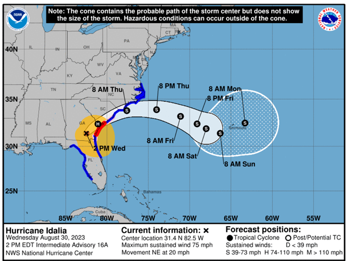
As of 2:00 p.m. CDT on August 30, Idalia has been downgraded to a CAT 1, with sustained winds of 75 mph. Weakening since touchdown in Northern Florida early this morning, Idalia continues moving in a north-northeast direction.
Heavy rainfall from the storm continues flooding along the Gulf Coast of Florida and the concern remains storm surges.
Here are the key points from the National Hurricane Center:
Significant impacts from storm surge will continue along the Gulf coast of Florida within the Storm Surge Warning through this evening. Dangerous storm surge is also expected along the southeastern U.S. coast within the Storm Surge Warning area tonight and Thursday. Residents in these areas should follow any advice given by local officials.
Damaging hurricane-force winds will occur where the core of Idalia moves across southern Georgia and southern South Carolina within the hurricane warning area through this evening. Residents in these areas should be prepared for long periods of power outages. Strong winds are also expected to spread northeastward across South Carolina and North Carolina through Thursday.
Residents should remain diligent, monitor the storm path and intensity, and follow any advice given by local officials. Also be prepared for long-duration of power outages.

Updated 5:00 AM CDT Wednesday August 30, 2023
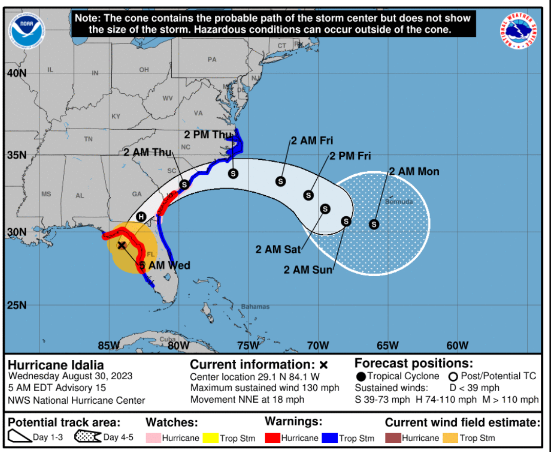
As of 5:00 a.m. EDT on August 30, Idalia strengthened to a Category 4 Hurricane overnight, with sustained winds of 130 mph, and a continued north – northeast trajectory into the Gulf of Mexico.
Heavy rainfall from the storm has already caused flooding along the Gulf Coast of Florida with additional flooding expected in most areas as the storm progresses.
Here are the key points from the National Hurricane Center:
- Storm surge watches and warnings are in effect for much of the Gulf Coast of Florida the Atlantic Coast of northern Florida into Georgia and South Carolina.
- Up to 12-16 feet of inundation being forecasted for areas along the Gulf Coast.
The biggest change to the intensity forecast is increased wind speeds over southeastern Georgia and South Carolina as the rapid motion and track close to the coast is expected to keep the system near hurricane strength for longer.
After landfall, Idalia is expected to move near or along the coast of Georgia and the Carolinas in 24-36 hours.
Strong winds will also spread inland across portions of northern Florida and southern Georgia near the track of the center of Idalia where Hurricane Warnings are in effect.
Residents should remain diligent, continue with preparation activities, monitor the storm path and intensity, and follow any advice given by local officials including any evacuation orders. Also be prepared for long-duration of power outages.
Damaging hurricane-force winds are also likely in portions of eastern Georgia and southeastern South Carolina where Hurricane Warnings are now in effect.

Updated 7:00 PM CDT Tuesday August 29, 2023
As of 7:00 p.m. CDT on August 29, Idalia strengthened to a Category 2 Hurricane, with sustained winds of 105 mph, and a continued north – northeast trajectory into the Gulf of Mexico.
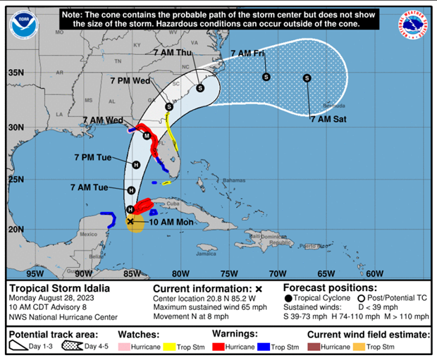
Hurricane Idalia was approximately 195 miles southwest of Tampa and 300 miles south of Tallahassee late this afternoon. It is predicted to intensify and become a major hurricane before making landfall. It is expected to reach the Big Bend coast of Florida on the Gulf Coast of Florida early on Wednesday as a Category 3 Hurricane with winds over 111 mph. After landfall, the center of Idalia is forecast to turn toward the northeast and east-northeast, moving near or along the coasts of Georgia, South Carolina, and North Carolina late Wednesday and Thursday.
Heavy rainfall will continue for areas of Florida and Georgia which could result in urban and flash flooding hazards. Storm surge watches and warnings are in effect for much of the Gulf Coast of Florida the Atlantic Coast of northern Florida into Georgia and South Carolina. Up to 12 feet of inundation is being forecasted for areas along the Gulf Coast.
Residents should remain diligent, continue with preparation activities, monitor the storm path and intensity, and follow any advice given by local officials. If you live near water and are told to evacuate, please follow direction, and leave for safety.
Updated 4:00 AM CDT Tuesday August 29, 2023
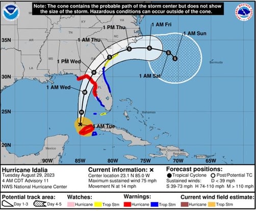
As of 4:00 a.m. on August 29 Idalia strengthened to a Category 1 Hurricane, with sustained winds of 75 mph, and a continued north – northeast trajectory into the Gulf of Mexico.
Hurricane Idalia is predicted to intensify before making landfall on the Gulf Coast of Florida early on Wednesday as a Category 3 Hurricane. While the storm track has not moved substantially, the track has moved slightly westward since yesterday.
Heavy rainfall will begin later today for areas of Florida and Georgia which could result in urban and flash flooding hazards. Storm surge watches and warnings are in effect for much of the Gulf Coast of Florida the Atlantic Coast of northern Florida into Georgia and South Carolina. Up to 12 feet of inundation is being forecasted for areas along the Gulf Coast.
Residents should remain diligent, continue with preparation activities, monitor the storm path and intensity, and follow any advice given by local officials.

1:00 p.m. CDT Monday August 28, 2023

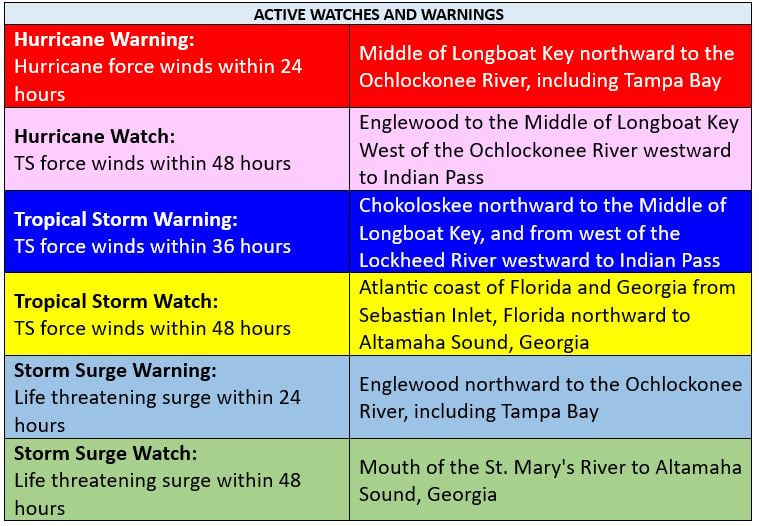
Tropical Storm Idalia is currently forecast to become a major, Category 3 hurricane before reaching the Gulf coast of Florida. The forecasted storm track brings increased risk for life-threatening storm surge and dangerous hurricane-force winds along portions of the West Coast of Florida and the Florida Panhandle beginning as early as late Tuesday. A storm surge between two feet and 11 feet are possible along the entirety of the Gulf coast of Florida with the highest levels between Chokoloskee to Indian Pass, FL, including Tampa Bay.

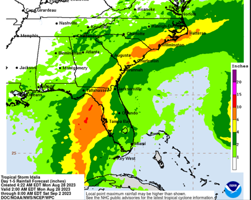
Heavy rainfall, up to 10 inches, is forecasted in widespread areas of Florida, the Florida Panhandle, and southern Georgia through Wednesday, spreading into eastern portions of South and North Carolina Wednesday and Thursday. Rain volume and intensity from the storm will bring flash flooding and urban flooding potentials in the affected areas.

Always keep up to date with the latest information from the National Hurricane Center about the storm and heed all warning or evacuation orders from the local authorities. Hurricanes and tropical storms pose a variety of threats to people and property. Storm surge and inland flooding have historically been the number one and two causes of loss of life during hurricanes. Hurricanes can also bring strong winds, tornados, rough surf, and rip currents.
Business owners should take all necessary precautions and preparation steps to protect their businesses from wind damage and flooding potential.
Steps you can take before the storm arrives are provided in the linked Hurricane Preparedness Guide. Key steps include:
- Activate your severe weather emergency action plan
- Clear storm and roof drains of debris
- Check roof condition and make any necessary last minute repairs
- Bring in or secure any loose furniture, signage, or planters outdoors
- Gather and install sandbags or flood protection materials.
Homeowners and residents should take all necessary precautionary and preparation steps to stay safe and protect their homes from wind damage and flooding potential.
Key steps you can take before the storm arrives are similar to above, but in addition;
- Follow local authorities guidance on evacuation
- Secure critical/important documents
- Take medications and pet food with you
- Do NOT drive through flood waters
In addition to the preparedness guide, see the disaster preparedness kit and post hurricane checklist for your reference and use.
Staying Safe After the Storm
Hurricane-related hazards do not immediately disappear with the storm clouds. After the storm clears, use generators safely, be careful not to overexert yourself, and do not venture into storm-damaged areas before it is safe and local authorities have given permission.
Teams at Risk Strategies are prepared and ready to assist you before, during and after the storm. If you have any questions regarding your insurance policy or preparation steps, please contact your Risk Strategies Account Team member or our Safety and Loss Control Team at safety@risk-strategies.com.
To report a claim directly to your insurance carrier(s), please visit https://www.risk-strategies.com/report-claim for a list of Insurer contact information.
If you are in need of remediation or additional claims assistance, please contact our Claims Team at claims@risk-strategies.com.


